Upper-level high pressure is lifting north of the area and this is opening up the tropics a little bit and as a result, we will slowly introduce showers to the forecast for the next three days.
With more clouds and some rain cooled air temperatures will be a little lower Sunday and Monday. As we dry hot Tuesday through Friday of next week temperatures will get hotter again.
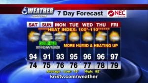
Tonight will be breezy muggy and very mild with a low of 74.
Saturday expect only isolated sea breeze showers still very hot and humid with a high of 94.
Saturday night we will have more clouds warm and sticky with a low of 76.
Sunday rainfall activity picks up a little bit with isolated to scattered showers not quite as hot with more clouds and a high of 91.
Enjoy your weekend. The tropics are still quiet.