We definitely saw a decrease in rainfall over South Texas this afternoon as upper-level high pressure is now in control of our weather pattern. The high pressure “dome” will stay in place for the remainder of the week and that will mean above normal temperatures sticking around and only a few stray thundershowers possible with afternoon heating. What forms will start at the coast and work inland.
SHORT-TERM FORECAST
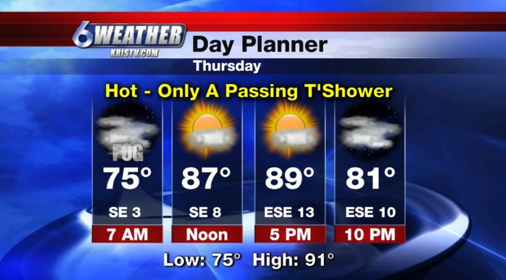
For tonight, expect some inland patchy fog reducing visibility down to 1-3 miles with partly cloudy skies and muggy conditions. Low: 75 Winds: SE 4-8MPH
Thursday afternoon will feature another round of above normal temperatures will mainly sunny skies and only a passing shower. High: 91 Winds: ESE 10-15MPH
Friday through the first half of the weekend, temperatures will stay near 90 with partly cloudy skies and increasing wind.
LOOKING AHEAD
Eyes then shift towards the west as a large upper-level trough will dig into the Rockies going into the weekend. That means some cooler air for those residents in that part of the country but not here in the Coastal Bend. What we will experience is an increase in winds. Look for southeasterly winds gusting up around 20-25mph on Sunday and Monday. With that increase of moisture coming in off the Gulf, essentially the trough is pulling all that in, we’ll begin to see more clouds and the opportunity for increased rainfall potential. It’ll begin slowly on Sunday and Monday where stray to isolated thundershowers will be possible, but by Tuesday and Wednesday of next week it will increase to scattered thundershowers.
TROPICS
Hurricane Leslie is a strong category 1 storm and is continuing to spin in the north-central Atlantic. An area of disturbed weather in the southern Caribbean is still having some issues getting its act together and not looking impressive on this Wednesday evening. The National Hurricane Center are monitoring it and only have a low chance of development over the next couple of days. We’ll be monitoring it. Category 3 Hurricane Sergio is off the coast of Mexico in the Pacific headed west and dangerous category 4 Hurricane Walaka is just west of the Hawaii and will continue to push north and does not look to impact the islands.
SUMMARY
Tonight: Mainly clear turning partly cloudy, some fog & stuffy…Low: 75 Winds: SE 4-8 MPH
Thursday: More sunshine, stray thundershowers…High: 91 Winds: ESE 10-15 MPH
Friday: Mainly sunny, hot, stray thundershowers …High: 90 Winds: SE 10-15 MPH
Saturday: Partly cloudy, breezy, stray thundershowers… High: 90 Winds: SE 10-20 MPH
Sunday: Windy, partly cloudy skies & stray thundershowers…High: 89 Winds: SSE 15-25 MPH
Monday: Windy, isolated thundershowers, still hot…High: 88 Winds: SE 15-25 MPH
Tuesday: More clouds, breezy, scattered thundershowers…High: 87 Winds: SE 10-20 MPH