A tropical wave in the western Gulf of Mexico brought us another round of showers and thundershowers in the Coastal Bend this afternoon. Early this morning, we just missed out on the activity as it remained offshore, but the afternoon seabreeze caught that rain along the coast and helped it push inland with the help of daytime heating.
There were a few locations along IH-37 that picked up some strong pockets of heavy downpours that caused some brief, but significant, flooding along the roads and in some neighborhoods. Doppler radar estimated around 1-3 inches fell in some locations. Officially out at the airport, over two tenths was registered. Out in Kingsville, there was over three inches officially recorded!
As we lose daytime heating, the rainfall will begin to diminish some; however a stray shower moving in from the Gulf is not out of the question. Overnight lows will fall back into the middle 70s with light winds and cause some patchy dense fog to form, especially for those who picked up some rainfall these last two days and also in low lying locations.
Upper-level high pressure will try to nudge a little farther south and become more of an influence in our weather patter over the next couple of days. With that said, we’re going to be in somewhat of a typical summer pattern as we look for a daily rain chance to exist with the afternoon seabreeze. Essentially showers spark near the coast early in the day and then migrate west through the afternoon before diminishing. Fewer locations will be impacted, but those spotty showers could dump a hefty amount of rain in a very short amount of time.
Look for temperatures to warm at or just above seasonal average Wednesday through Saturday under partly cloudy skies. Winds will really become a nuisance by the end of the week and on into the weekend and early next week.
Summary:
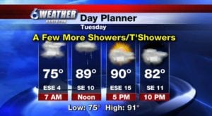
Tonight: Partly to mostly cloudy, humid & warm, stray showers…Low: 75 Winds: SE 4-8 MPH
Tuesday: Mainly cloudy with stray/isolated showers/thundershowers…High: 91 Winds: ESE 10-20 MPH
Wednesday: Partly cloudy, hot and humid, stray seabreeze showers…High: 94 Winds: SE 10-20 MPH
Thursday: Partly cloudy, hot and humid, stray seabreeze showers…High: 94 Winds: SE 10-20 MPH
Friday: Partly cloudy, hot and humid, stray seabreeze showers, increasing wind …High: 95 Winds: SSE 15-25 MPH
Saturday: Partly cloudy, stray seabreeze showers and breezy… High: 94 Winds: SE 15-25 MPH
Sunday: Mix of clouds and sun, stray seabreeze showers and windy …High: 94 Winds: SSE 20-25 MPH